

MY ROLE
Pinpoint is a personal project that I began developing to better familiarize myself with product design and entrepreneurship. I conducted tech and market research, designed a brand identity, and am currently researching feasible tech specifications.
UX Research • Tech Research • Concept Dev
Branding • User Flows • Entrepreneurship

the CHALLENGE
In a high-tech world capable of quantum computing and humanoid robots doing backflips, it's bizarre that losing personal belongings is still such a huge inconvenience. Misplaced keys can ruin an entire day, and a lost wallet or phone can ruin an entire paycheck. Many products have attempted to address this problem, but few deploy technologies that provide a practical or effective solution. There HAS to be a better way!
I began asking myself questions about an imaginary product that solves these issues. How does it work? What sets it apart from the market? How is it better at improving the livelihood of its users?
The goal became a personal item tracker that:
• Utilizes technology more efficiently than competitors
• Implements unique and exclusive features
• Provides an intuitive and visually refined experience
• Is offered at a consumer friendly price point

Understanding the Market
Analyzing existing item trackers would allow me to identify specific opportunities for functionality/design improvement. It would also help me form clearer expectations and goals for the product.
Technical Feasibility
To the best of my non-engineer abilities, a goal of mine was to propose a reasonably plausible solution for the product's functionality. Accounting for this would require research in positioning systems, manufacturing, and other unfamiliar topics.
Startup Considerations
I did my best to reduce unit cost by proposing open-source software and practical manufacturing materials. I also explored unique ways to monetize through mobile advertising and proximity marketing.

THE approach
My first step was to conduct a competitive analysis of the leading products in the Bluetooth item tracking market: Tile, Trackr, and Protag Duet (this was pre-AirTag). I then broke my evaluation down into six main categories:
• Feature Audit
• Censor Specs
• Function Evaluation
• Brand Evaluation
• App Evaluation
• Ratings & Reviews
The gallery below showcases the full analysis. Use the arrows on your screen or keyboard to cycle through the images.
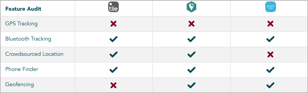


Competitive Analysis Conclusions
While Bluetooth Low Energy (BLE) is great, it doesn’t seem optimal for tracking and finding personal items. Your phone’s connection to the tracker tags can be disrupted by physical barriers and the range is deceptively short.
For items outside of Bluetooth range, many trackers offer a "crowd-finding" feature that utilizes location data from other users to track down your missing tag. It's a good idea, but isn't well sourced enough to be effective. Tile, which presumably has the largest crowd-finding network of any item tracker, has a considerable number of negative reviews attributed to the product's inefficacy out of Bluetooth range.
Real
User
Reviews:
"Really the only use for them is finding things around the house. They eventually die without warning."
— Tile
"Poor battery life. They lose connection all the time, and the bluetooth range is really bad."
— Trackr
"Virtually unusable. Sometimes it connects, and sometime's it doesn't."
— Duet
Despite the ~$20 price tag for just one of these trackers, BLE does not appear to be inherently expensive to implement. A bare-bones item tracker is listed for $2.50 per tag on Amazon and appears to offer the same basic functionality as the Tile/Trackr/Duet, along with an accompanying app. Consumers are paying a substantial markup for a nicer form factor, better branding, and an additional crowd-finding feature that doesn’t work.
Tile proves that, if executed properly, BLE can help you find misplaced things inside an average single story home. None of the products I analyzed, however, provided a sufficient solution for items outside of Bluetooth range.
User Personas
Based on my competitive analysis and target price point, I created three detailed user personas to represent consumers in my primary audience. Click an image to enlarge.


I may have went a little overboard here… but these personas did become a useful reference tool to help steer decisions towards user satisfaction.
After identifying what the product needed and who it was for, the next step was to determine how it would function. I began researching location-based technologies with the goal of proposing a cost-effective and reasonably feasible solution.

the research
After compiling ~30 pages of notes and sources, I formed a makeshift understanding of indoor and outdoor location-based technologies (paging doctors Dunning & Kruger). This section details how these processes function along with their pros and cons. If you're yawning, click here to skip the tech research.

Global Positioning System (GPS)
When you use your phone’s GPS, you receive radio signals from at least three different orbiting satellites. These signals, traveling at the speed of light, include the exact time they were emitted with ultra-specific accuracy due to atomic clocks. Based on these timestamps and how long it takes each signal to arrive, your phone is able to calculate your distance from each GPS satellite. Finally, it uses these ≥3 values to perform a process called trilateration and approximates your location.

Poor atmospheric conditions can inhibit the time it takes for satellite radio signals to reach the Earth’s surface, thus diminishing the accuracy of GPS. On a sunny day with minimal interference, your GPS can deliver location accuracy within ~10ft.
Bluetooth Low Energy (BLE)
If your phone is near you, navigate to your Bluetooth settings and hit “On” or “Scan”. As the loading wheel spins, your phone emits short-range radio waves that scan the area for potential Bluetooth devices to connect to. If an accessible device is within range, it provides your phone with profile information that gets displayed on your screen. When you select a profile to pair with, the two devices use radio communication to quickly establish a wireless network capable of transferring data in both directions (as long as the devices remain connected).
Bluetooth signals can be disrupted by physical barriers and other electronic devices, making indoor connections less reliable. Different classes and antenna configurations also provide different ranges, since they utilize different power outputs. Most phones use Class 2 BLE, which generally provides a range of ~30ft.
Cell Tower Positioning
If your phone is in range of three or more cell towers, it's possible to geolocate it using a process called triangulation. Each tower identifies which of its three 120° sectors your signal resides in and estimates your distance based on signal strength. The towers then combine their data and use the overlapping information to approximate your device’s location within ~3/4 of a mile.
Wi-Fi Positioning
Over the last decade, Google, Apple, and various open-source platforms have quietly aggregated location data for millions of Wi-Fi access points. By constantly logging the physical location and publicly accessible mac addresses of each Wi-Fi network, these databases are able to remain up-to-date and functionally useful.
For example, let’s say your phone detects multiple Wi-Fi networks. If the physical locations of those networks have been logged, and your device is close enough to detect them, your location can be reasonably triangulated.

The Discovery
My original proposal revolved around a combination of BLE and an assisted form of GPS known as Real Time Kinematics (RTK). Often utilized in farmland surveying, RTK accounts for atmospheric interference with a fixed-location base station that references the same satellites as your GPS receiver and provides differential corrections in real time. Successful RTK delivers an absurd 1-3 inch location accuracy, which would be more than sufficient for locating item’s outside of Bluetooth range.
This product would include an easy-to-install home panel (RTK base station) paired with coin-sized tracking tags and an integrated mobile app. The home panel’s larger power capabilities would also allow for a Class 1 Bluetooth antenna, creating a larger and more reliable BLE range. It would also allow proper GeoFencing that alerts users when leaving necessities at home.
I dubbed the product Homeplate and began working on the branding while also mapping out the home and mobile experience.

the vision
After delving deeper into the production of Homeplate, I began questioning whether it offered the optimal tech solution. Firstly, the additional RTK base station would push the price point much higher than my original goal. The tracking tags would also need to be equipped with GPS receivers, which raised concerns regarding form factor and battery/power output. Homeplate was quickly becoming an entirely different product than I envisioned.
On my way back to the drawing board, I stumbled upon an up and coming technology called Magnetic Positioning.
Animals like birds and bats are able to detect Earth’s magnetic field and rely on it for wayfinding. While humans can’t inherently do the same, our technology can. And while its military use can be traced back to the 1970’s, magnetic positioning’s commercial application seems to be an untapped field.

introducing: pinpoint
Pinpoint is a first-of-its kind tracker tag that utilizes the Earth’s magnetic field for reliable indoor item finding. Unlike BLE, magnetic positioning excels in its accuracy and does not rely on your proximity to the tracker tag. For outdoor item finding, Pinpoint utilizes Cell Tower & Wi-Fi Positioning via open source databases.
Logo
The pinpoint logo represents a modernized take on the classic iconography of a horseshoe magnet. It also resembles common visualizations of the Earth’s magnetic poles.
The wavy background pattern alludes to maps of the world’s magnetism and will be used throughout the brand identity.
How It Works
The Earth produces a natural magnetic field that is affected by our man-made structures. Because of this, each building has a unique magnetic fingerprint that can be precisely mapped to a building’s specific floor plan. Once this map has been generated, a magnetometer can accurately determine where it is within the map by assessing its magnetic reading.

Through the Pinpoint app, users initiate an oboarding feature called “Create Map.” As the user walks through their home, work, or wherever, the magnetometer in their phone records the magnetic data and maps it to their floor plan.
Once this map exists, the user’s phone and tracker tags (also equipped with magnetometers) can be reliably located within the mapped building down to ~3 feet.

Because of this technology, Pinpoint is not susceptible to the range limitations and connection unreliability of Bluetooth trackers. Not to mention, the location of the missing tags are visually shown to the user on a map, as opposed to BLE trackers which rely solely on emitting a beep that you need to echolocate.
Deployment: Magnetic Positioning
IndoorAtlas, the industry pioneer of this technology, offers a partner program which provides technical training in their proprietary magnetic positioning system. They encourage innovation using their product, even providing a deployment workflow for partners and access to their cross-platform SDK.

I’ve exchanged briefly with IndoorAtlas and fully believe this solution to be feasible. While it does provide more of a technical challenge than the established Bluetooth, that is the case for anything new attempting to innovate, and the advantages in functionality and user experience are significant.
Deployment: Cell Tower & Wi-Fi Positioning
GPS receivers tend to be too large and costly to reasonably implement in a product like this. Instead, an algorithm that utilizes Cell Tower & Wi-Fi positioning in tandem would be a cost effective solution for outdoor positioning, as there are opensource databases and communities dedicated to these techniques.
While this saves in overhead and cost-per-unit, it would necessitate a 4G connection in the trackers, likely via SIM card. This would require either a subscription model on the user end, or ideally, some sort of company agreement with a telecom provider.
Deployment: Tracker Tags
Like any existing item tracker, Pinpoint’s form factor needs to be small enough to fit comfortably on a key-chain, an animal’s collar, adhered to a laptop, etc.
To my understanding, the tracker tags would require the following hardware:
- Magnetometer
- SIM Card
- WiFi Module (Arduino?)
- Microcontroller (Arduino?)
- Chargeable Battery
The next steps are to learn more about how to implement this technology conjointly, and hopefully produce a non-size-contingent prototype as a proof of concept.


